SEWER AND COASTAL FLOOD PROTECTION MASTER PLAN
Final Recommendation Summary Report
Coastal Flood Protection
A flood risk assessment was completed in 2019 (East Riverside Flood Risk Assessment Study) to evaluate the integrity of the existing landform barrier system and to determine whether it will be adequate to provide protection under various conditions. Based on recommendations of this study and further review of the City’s overland drainage system, opportunities to expand this coastal flooding system were identified.
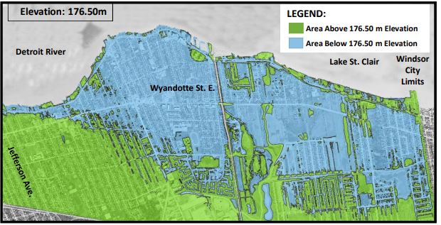
In late-Spring 2020, water levels in the Lake Erie, Detroit River and Lake St. Clair system reached a historic high water surface elevation above 176.0 meters (m) . By 2050, studies project static high water levels of 176.50m, with instantaneous high water levels from wind effects as high as 176.80m. Water level elevations will be continuously monitored and flood protection elevations will be reassessed in 2030.
Based on these elevations, a large portion of the Riverside Area is at risk of basement flooding. (See map below)
The purpose of Coastal Flood Protection:
-
Protect in-land areas from high lake/river levels.
-
Protect low lying residents, who live North of Riverside Dr., from overland surface flooding on Riverside Dr.
-
Utilize existing private property grades to meet minimum protection levels.
-
Prevent backflow of high lake levels into the sanitary and storm sewers systems.